• Skip navigation
  • Skip to navigation
  • Skip to the bottom
Simulate organization breadcrumb open Simulate organization breadcrumb close
Friedrich-Alexander-Universität GeoThermal/GeoEnergy
  • FAUTo the central FAU website
  1. Friedrich-Alexander-Universität
  2. Naturwissenschaftliche Fakultät
Suche öffnen
  • de
  • Campo
  • StudOn
  • FAUdir
  • Jobs
  • Map
  • Help
  1. Friedrich-Alexander-Universität
  2. Naturwissenschaftliche Fakultät
Friedrich-Alexander-Universität GeoThermal/GeoEnergy
Navigation Navigation close
  • Research
    • Research Topics
      • Deep Geothermal Energy
        • Geothermal-Alliance Bavaria – Projects at the GZN
        • Geothermal-Alliance Bavaria – Project participants at the GZN
        • Geothermal-Alliance Bavaria – Official website
      • Shallow Geothermal Energy
      • Reservoir Analysis
    • Projects
    • Publications
    • Recent Dissemination
    Portal Research
  • Research Groups
    • People
    • Lab and field equipment
    • Reservation of the labratories
    Portal Research Groups
  • MSc-Program
    • Curriculum
    • Job perspectives
    • Training staff
    • Enrollment
    • Downloads
    • Bachelor’s thesis
    • Master’s thesis
    Portal MSc-Program
  • News
    • Announcements
    • Press Releases
    • Scientific Outreach
    • Events
    • 3rd School on Sandstone Diagenesis
    • Seismic investigations in northern Bavaria
    Portal News
  1. Home
  2. Research Topics
  3. Shallow Geothermal Energy
  4. GIS-based Estimation of Geothermal Potential

GIS-based Estimation of Geothermal Potential

In page navigation: Research Topics
  • Deep Geothermal Energy
  • Shallow Geothermal Energy
    • Horizontal Systems (Very Shallow Geothermal Energy)
    • Vertical Systems
    • District Heating and Cooling
    • GIS-based Estimation of Geothermal Potential
    • Underground cables
    • Sustainable Flood Control
  • Reservoir Analysis

GIS-based Estimation of Geothermal Potential

GIS-based Estimation of Geothermal Potential

Illustration of the thermal conductivity (Thermomap.eu, 2020)
Section of Südlink (Bertermann et al., 2020)
Distribution of the number of frost days (Bertermann et al., 2020)
Illustration of the thermal conductivity (Thermomap.eu, 2020)
Section of Südlink (Bertermann et al., 2020)
Distribution of the number of frost days (Bertermann et al., 2020)

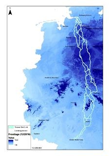
With a geographic information system (GIS), field data can be georeferenced, processed, edited and digitally visualised. This offers countless possibilities, including the estimation of geothermal potentials for shallow geothermal systems, based on soil maps, and the integration of geological and hydrogeological information.
Based on such pedotransfer functions, the working group Shallow Geothermal Energy determines essential system parameters for potential estimates of shallow, earth-coupled heat exchanger systems. The thermal soil properties parameters determined here can also be used for heat transport calculations within the environment of underground high-voltage transmission lines (see underground cables).
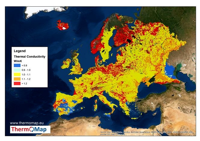
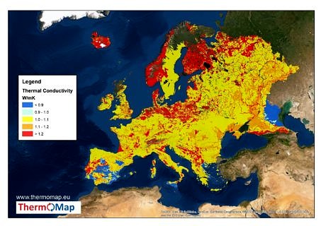
We realize GIS-based analyses on a municipal level in cooperation with local authorities, but also on (inter)national level. For example, within the framework of the EU project ThermoMap, very shallow geothermal potentials in Europe are mapped. This interactive map is available at:
www.thermomap.eu

Contact

Jocic, Nikola

Jocic, Nikola

Scientific Staff Member
  • Email: nikola.jocic@fau.de

All staff members

  • Erarbeitung eines Handlungsleitfadens zur Abschätzung der oberflächennahen geothermischen Potentiale in ländlichen Gemeinden

    (Third Party Funds Single)

    Term: 1st August 2019 - 31st December 2020
    Abstract

    ab

    →More information

All projects of the chair

GeoZentrum Nordbayern
Friedrich-Alexander-Universität Erlangen-Nürnberg

Schlossgarten 5
91054 Erlangen
  • Legal notice
  • Privacy
  • Accessibility
  • Facebook
  • RSS Feed
  • Twitter
  • Xing
Up